
 Linville Gorge is a rugged trek for even the most experienced hiker.
 It could be the challenge. Or the views. Maybe it’s the no-guilt, post-hike beer and food. No matter what your motivation might be, North Carolina has some gnarly hikes ready to be traversed by the most ardent of adventurers.
So if you’re into burning quads and having your breath taken away by steep climbs and stunning vistas, these four hikes are for you.
Mount Winterstar

Rob Glover
Mount Mitchell is hands-down the most famous of the peaks in the Black Mountain Range. It is, after all, the highest precipice this side of the mighty Mississippi, and a worthy peak to bag for any Eastern hiker. But for the mile-per-mile toughest trek in the Black Mountains, look five miles north to Mount Winterstar.
The nearly nine-mile roundtrip hike on the Colbert Ridge Trail to the top of Winterstar isn’t as long as the trip to its famous southern cousin. And at 3,000 total vertical feet, its incline falls a little short, too.
The cred for hikers who summit Mount Winterstar comes instead from the trail itself. Compared to the relatively worn and smooth paths at Mitchell, Colbert Ridge is a merciless series of rocks, huge roots, and downed trees that never seem to let up. The reward is a view you won’t have share with the hundred motorists who drove to the top of Mitchell. The subtle summit of Winterstar is a much more subdued place from which to ponder the grandeur of life.
Look for the Colbert Ridge Trailhead near the Carolina Hemlocks Campground on Highway 80.
Grandfather Mountain State Park

Kolin Toney
On one side of what is now Grandfather Mountain State Park (formerly privately owned), families stroll a couple hundred feet from a parking lot to the mile-high swinging bridge, catching some views and stopping at the snack shop on the way back. On the other side of the park, however, the hardiest of hikers begin one of the most challenging treks in North Carolina.
Along the nearly five-mile trek from the Boone Fork Trailhead off Highway 321 to the swinging bridge at the visitor’s center, hikers will encounter knee-shaking boulder scrambles, narrow ladders, nerve-wracking rock ledges, and chutes that almost require a butt-scoot to traverse. Along the way, however, intrepid explorers are rewarded with amazing 360-degree views at 5,964-foot Calloway Peak and a challenge unlike any other in the state.
Begin your hike at the Boone Fork Parking Area on Highway 221. From there, take the Tanawha Trail south to the Daniel Boone Scout Trail and follow to the Grandfather Trail.
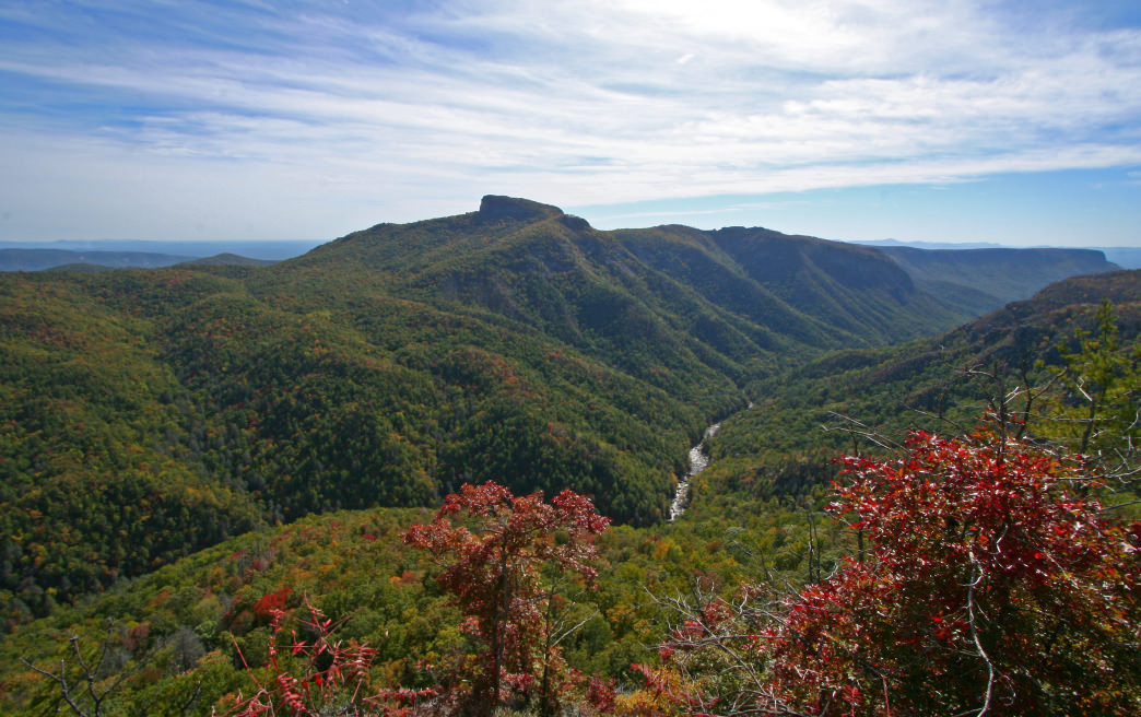
Linville Gorge

Joseph
It’s not hard to imagine that a broad chasm boasting 2,000-foot high walls would present a certain element of difficulty to hikers. Such is the reality of hiking at Linville Gorge. On either side of the rift, trails descend and, of course, ascend with brutal quickness.
While there are few treks in the gorge that can be called easy, the most rugged and wild adventures begin from the western rim. Here, even getting to the trailhead is a challenge, requiring a muddy, bumpy ride on the Kistler Highway. Once on the trail, regardless of which option you choose to hike down into the gorge, expect steep, uneven trails, and plenty of misdirection.
Once at the bottom, you’ll know why you came. The Linville River, architect of this great valley, rushes past rocky banks and over sudden falls, offering a dramatic backdrop for one of the most immersive natural experiences in the state.
Begin your visit with a stop at the Linville Falls parking lot. Then head south on the Kistler Memorial Highway to reach any of the trailheads that dip into the gorge.
Yellow Mountain

Philip Bradley
The hike to the top of Yellow Mountain may skew towards the tame end of this list of imposing trails, but don’t let that fool you. The 10-plus mile round trip to the historic fire tower that tops Yellow Mountain should not be taken lightly.
The trail begins at an unassuming wide spot on Bucks Creek Road about 10 miles from Cashiers, North Carolina. Rising gently at first, the trek is a pleasant walk in the woods. By the end, however, the trail crests three knobs, rising and falling sharply with each one. Most of the trail is heavily wooded, creating a zen-like experience even while your heart pumps wildly. But then, just as you begin to wonder if the endless undulations will ever end, the trees give way to an impossibly distant view that reaches into Georgia.
Begin your hike at the trailhead on Buck’s Creek Road. Look for a wide spot in the road about little more than 2 miles from its intersection with Highway 64.
Tips for these tough hikes
-
Assume your average hiking pace will be cut in half on these tricky trails. Plan accordingly if you hope to finish before dark—which you most certainly want to do at Linville Gorge unless you’re backpacking.
-
Even if you don’t normally use them, these are the trails that hiking poles were made for. They can help you up the steepest climbs and, perhaps more importantly, they can reduce the pounding your knees will endure on the way back down.
-
Dogs are allowed on each of these hikes. The trek at Grandfather Mountain, with its many ladders, may be worth an initial visit without your four-legged bestie.
Originally written by RootsRated.
Featured image provided by Alan Cressler