
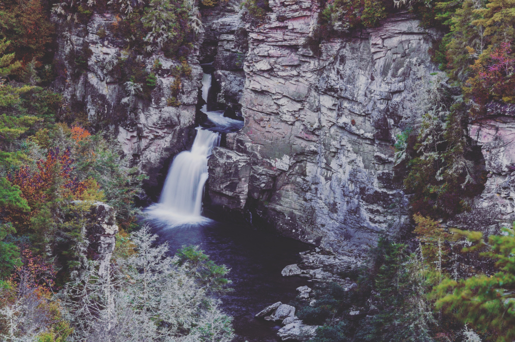
 Upper and Lower Linville Falls are a powerful spectacle in every season, but particularly in the splendor of autumn and the stark monochrome of winter.
 Winter brings a whole different mood to the Linville Gorge.
Fauna, stripped bare of its foliage, gives way to views not possible through the full growth of summer. A dusting of snow contrasts with the gray of winter and huge icicles cling to their rocky outcropping mounts. But exploring the west side of the gorge is no walk in the park. The trails there are among the most unapologetically rugged in North Carolina.
Nevertheless, we suggest four reasons why you might consider a gorge trip.
1. Getting there is half the fun

Paul Geist
The challenge of hiking the western ridge of the “big ditch” begins long before you ever set foot on the trail. Turning off Interstate 40 and onto 181 north, the road takes on the twists, turns, and undulations typical of this part of the world. Reaching the upper parking lot near the Linville Falls Trailhead and having a glance at what lays ahead, however, is where things get really interesting.
Running the length of the gorge along its western edge, the Kistler Memorial Highway provides the only access to each trailhead. Wildly misdesignated as a “highway,” the hilly dirt road is bumpy and difficult in the best of times. During winter—when frequent rain, snow, and ice create ruts and mounds of thick, slick red clay and mud—navigating the highway is like driving on peanut butter covered in pudding. Four-wheel drive trucks slip and slide while the tires of sedans spin furiously to gain enough purchase for an uphill attack.
The good news is that each trailhead along the highway is well marked and comes complete with several parking spots.
2. To renew your orienteering merit badge

Rob Glover
On the map, it looks so simple: Choose one of the trails that leads from the Kistler Highway and drops to the bottom of the gorge. Then turn right or left onto the Linville Gorge Trail and walk along the river, soaking in the beauty and serenity of nature.
This is rarely what happens. What's more likely is you'll hop on a named trail, walk a mile, come to a junction that’s not noted on your official Nat Geo map, choose the wrong direction, and wind up next to the river with no noticeable way to travel along it. Welcome to the gorge.
Your best bet is to remember the following: 1) Hiking at Linville is an exploration, so leave plenty of time to roam. 2) If you go uphill, you have a decent chance of eventually hitting the dirt road and finding your car. 3) Grab a map from the locals who spend lots of time in the Gorge.
3. Your knees lost a bet

Rob Glover
For a dozen miles, the Linville River cuts a deep groove through a rocky, tree-covered expanse of unbroken wilderness. Depending on where you’re standing, the bottom of this giant rut may be 2,000 feet below you. This drastic change in elevation creates both views and trails that will take your breath away.
There are five trails that take you from ridge to river on the western side of the gorge, all of which lose all their elevation in less than two miles. But they’re not just steep. Most of these trails are among the most rugged in North Carolina, requiring one to scramble over rocks and huge downed trees, and shimmy through dense undergrowth. Many spots along these paths rarely see daylight so the way can remain slick with ice and slush long after more civilized areas have thawed. Progress is sometimes slowed to a crawl. Your knees may be a bit tender come Monday morning.
4. Getting lost is the new "found"

Steve Bassett
There is no such thing as a boring hike from the western rim of Linville Gorge in winter. On the ride home you will talk about how you had to slide on your backside to get past a sheet of ice. You’ll describe how you felt standing on a rock outcropping 2,000 feet below the rim watching the icy green/blue river push through sluggish winter pools. You’ll compare immense natural ice sculptures–giant frosted stalactites dipping into rushing water from the rocky chasm walls. And, of course, you’ll wonder where you went wrong and how you lost the trail. But you’ll be happy you did because it led you to that “one spot” that made you feel like the first person to ever set foot there.

Rob Glover
How to explore the gorge:
Perhaps the most hospitable route into the gorge, though still not to be taken lightly, is the Pine Gap Trail. Since it is also the northern most trailhead–requiring the least amount of time on the Kistler–it is a great option for a first-time exploration.
Once you are in the gorge, following the river on the Linville Gorge Trail, there are several optional trails that will take you back to the top and to Kistler Highway. Once you’ve hiked back out you can simply walk the road back to your car.
Trails like these are the reason they make trekking poles, so it’s a great idea to bring a pair along. Allow for plenty of time to explore (aka get a little lost). Expect to hike at about half the speed you would on a typical mountain trail. Start early and bring a headlamp just in case. Night comes early at the bottom of a gorge.
Originally written by RootsRated.
Featured image provided by Stephen