
 House Mountain offers stunning views any time of the year.
 Just beyond the boundaries of the city, hovering over the small town of Corryton, Tennessee, is House Mountain: Knox County’s highest peak and likely its most beautiful outdoor spot. Supposedly so named for the roof-like slant of its twin summits, House is home to a wide array of blossoming flowers, climbing vines, and waving trees, including the high-limbed, thick-trunked tulip poplar, Tennessee’s state tree.
House Mountain is a wonderful hiking destination year-round and offers something a little different in every season. In the summer, the shaded trail grants a pleasant respite from the heat, and visitors in these more humid months will often be treated to a pleasant breeze rolling across the summit’s rock outcroppings. In fall, the wide array of trees catch fire with warm reds, oranges, and yellows, lighting the mountain in a beautiful autumn display. In the coldest months, after all the leaves have fallen, hikers are treated to clearer views through the bare trees to the stark, chilly valley below. And finally in spring, when winter has relinquished its hold, the mountain comes alive with beautiful wildflowers showing off their bright blossoming colors, calling hikers farther into its verdant depths.
If House has piqued your interest, stay with us as we tell you everything you need to know about exploring Knox County’s highest point.
Starting Out

Logan Mahan
Near the parking lot at House Mountain you’ll find a map and information kiosk and a latrine-style bathroom, but no potable water is available here or anywhere along the trail, so hikers should bring plenty of water for themselves and any furry friends they bring along. Yes, unlike the Smokies, pets are welcome on all the trails as long as they’re kept under restraint. The full hike (up, out to both overlooks, and back) is about 4.5 miles and will take most hikers about 3 or 4 hours to complete. A hike up House Mountain should not be attempted if it has just rained, because the trail is very prone to erosion. Hikers should also watch the weather during their hike, and descend quickly, if a storm rolls in. Because this is the highest point around, House Mountain has quite a few lighting strikes throughout the year.
When you’re ready, head down the trail near the bathrooms, past the small covered picnic area. Continue straight past the Left Sawmill Loop sign. You’ll pop in and out of thick wooded areas for a short while until you reach a fork with a trailhead junction sign. From here, you can turn right and climb the blue-blazed Mountain Trail up to the center of the Crest Trail or you can turn left and take the slightly shorter (but a bit steeper) white-blazed West Overlook Trail, which will take you to the far southwestern edge of the Crest Trail. We typically like to go up the Mountain Trail and come back down the West Overlook, but either way works.
Mountain Trail (Blue Blazes)

Logan Mahan
The Mountain Trail curves across the southeastern side of House Mountain, climbing for 1 mile to its intersection with the Crest Trail. Along the Mountain Trail, you'll encounter a diverse and vibrant understory of plant life through which you may be able to see the ridges just south of the mountain. If you go in the morning, you’ll likely be treated to a dramatic, thick fog rolling up from the valley into the Mountain Trail woods. Depending on the time of year you visit, you may also hear the songs of migratory birds. House Mountain is a popular destination for birders, and visitors may see and hear scarlet tanagers, warblers, ruffed grouse, hawks, woodpeckers, and many other birds on the mountain.

Logan Mahan
Erosion from hikers have worn down sections of the trail here, and you'll see some plastic fences with posted requests to stay on the trail. Make sure you heed these and resist cutting the switchbacks. Towards the top of the Mountain Trail, you’ll encounter a steeper climb, and you may see an old spur trail. Make sure you stay on the Mountain Trail here, marked by the blue blazes and arrows. Once you start hitting a super steep climb with switchbacks, you'll know that you're almost finished with this leg. Push a little more until you reach the end of the Mountain Trail and its intersection of the Crest Trail.
The Crest Trail (Red Blazes)

Logan Mahan
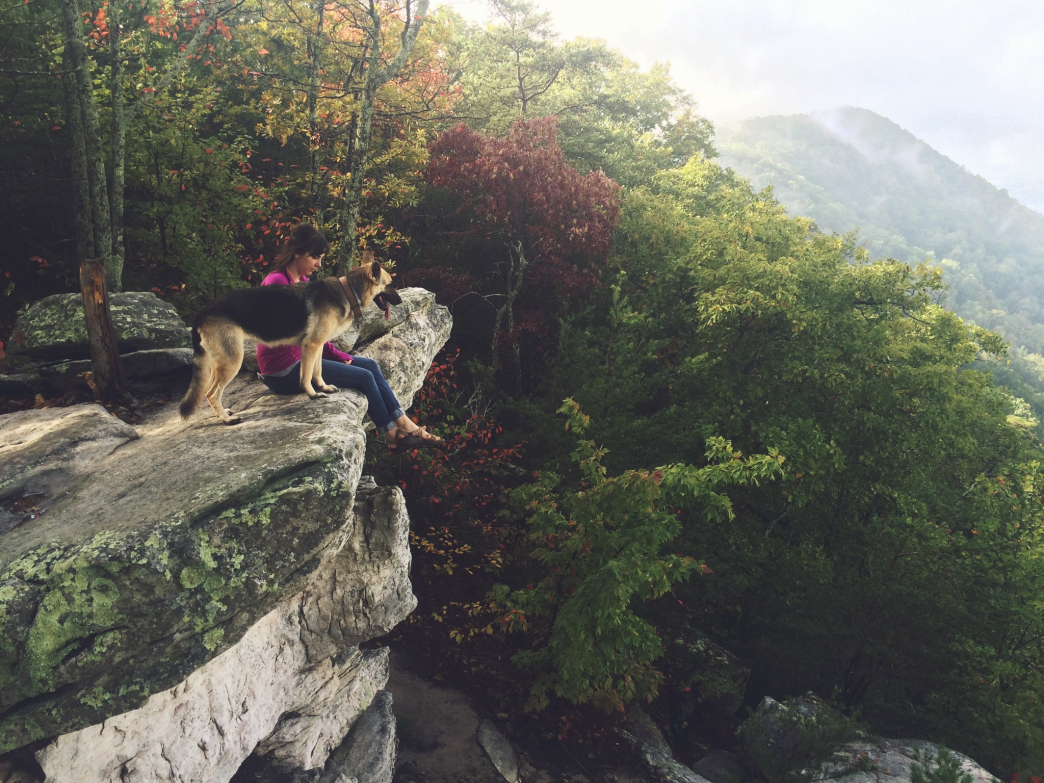
The Crest Trail extends across the top of the mountain, 1.5 miles in total length, and offers a mountaintop experience unlike any available in Knox County. From its intersection with the Mountain Trail, hikers often take a left, stopping at the West End Overlook to look out over the hills and ridges of East Tennessee before turning down the West End Overlook Trail to loop back around to the first trail junction below. On a clear day, you can see the Smoky Mountains to the south, the Cumberland Mountains to the north, and you might even catch a glimpse of downtown Knoxville from the western overlook. These are stunning views, especially for being so close to Knoxville, and they are often the only views House Mountain hikers see during their visit. Because the Mountain Trail, western section of the Crest Trail, and the Western Overlook Trail form a loop, many visitors to the mountain skip the eastern overlook, which we think is a pity.

Logan Mahan
The eastern end of the Crest Trail—both the overlook itself and the path you take to get there—is possibly the best section of the entire trail system at House Mountain. Dense copses of trees skirt the trail that leads to the Eastern Overlook, where large rock outcroppings allow hikers to see Clinch Mountain to the northeast and the opposite peak of House Mountain to the southwest.
West Overlook Trail (White Blazes)

Logan Mahan
From the far western end of the Crest Trail, hikers can descend down the West Overlook Trail 0.8 miles back to the trail junction. The initial descent is a steep one, requiring hikers to scramble down a few rocks and scoot down some steep declines. After these though, the trail offers a relatively easy descent, with several switchbacks easing your path down. Again, remember to resist the urge to cut the switchbacks: this will not only save your knees and ankles but also help protect the trail from erosion. Once you get back to the trail junction, follow the short connector back to the parking lot, hop in your car, and enjoy the (very short!) drive home as you revel in your excitement at finding such a breathtaking hike so close to Knoxville.
Getting There

Logan Mahan
Last time we checked the google maps destination for “House Mountain State Natural Area” won’t take you to the trailhead parking lot, so either plug in “9601 Hogskin Road” into your navigation app or follow the directions below.
From Knoxville, take I-40 East. Exit on U.S. Highway 11 West/Rutledge Pike and head north and east on Rutledge Pike. After about 10 miles, look for the “House Mountain State Park” sign on the right and then turn left on Idumea Road. Turn left on Hogskin Road. Then the parking area is less than a mile down on your right.
You can find a full map and more info about the House Mountain trails on Knox County's website and find more great hikes near Knoxville here. Happy trails!
Originally written by RootsRated.
Featured image provided by Logan Mahan