
 Shuckstack.
 The climb into the Smoky Mountains from Fontana Dam is notorious among Appalachian Trail thru-hikers, and for good reason. Heading north, the grueling ascent gains more than 2,100 feet in the first 3.5 miles, continuing on to peak at Spence Field (almost 5,000 feet in elevation), and then heading back down to take in the views at the old Shuckstack Fire Tower.
Fortunately, there are other adventurous options—though equally strenuous—to get into the Smokies and take in the views from Shuckstack without mounting the frontal assault on the mountains from the Appalachian Trail. Veer right from the AT trailhead at Fontana Dam and instead set out along the Lakeshore Trail, a more leisurely start with gradual dips and gains along the banks of Fontana Dam, before connecting with the Eagle Creek Trail just past backcountry campsite #90, where you’ll cross a small creek along a log footbridge, before heading into the heart of the Smokies.

Clay Duda
Give yourself three days to make this 32-mile loop, following Eagle Creek in full to where the trail connects to Spence Field on the Appalachian Trail before heading south along the AT back towards Fontana Dam. It’s not an unachieveable feat if you plan appropriately and pace yourself, though it’s a trek only advised for more experienced hikers. The reward is near-panoramic views of the Smoky Mountains and Fontana Lake from atop Shuckstack Fire Tower, the possibility of encountering deer and bear and other wildlife, and finding seclusion in one of the most visited national parks in the country.
Day 1: Up Eagle Creek to the Appalachian Trail
Your first day is somewhat easy going, starting at the top of Fontana Dam. As you meander along Lakeshore trail, enjoy the sweeping views of Fontana Lake before turning into the woodlands. Shuckstack Fire Tower hides behind the trees just a few miles to the north.

Clay Duda
Head north along the Lakeshore trail, connecting with Eagle Creek. Be prepared for more than 20 creek crossings, none of which have footbridges or much else except slick river rocks to hop across. It’s worth bringing a sturdy set of hiking poles, breathable shoes that can dry overnight, and at least one change of socks.
The trail is lined with the leafy rhododendron the Smokies are known for, scattering white flowers along the way in mid- to late-summer. Rarely will you lose sight of the waterway, which gradually narrows as you forge deeper into the mountains. Deep in a ravine, little more than thick foliage and the occasional wildlife sighting will come into view. Keep a keen eye out for bears throughout the trip.

Clay Duda
Push it to make the last campsite on the trail, #97, about 11.5 miles from the trailhead, and rest up. Thus far Eagle Creek has only gained about 500 feet, and Day 2 starts with a push to the summit at Spence Field, more than 2,000 feet above.
Day 2: The Summit
Eagle Creek is a slightly easier ascent than the AT from Fontana, but only because it’s stretched over nearly five miles instead of 3.5—you’ll still have to climb to the top. A small metal pipe offers fresh water just below the Spence Field Shelter. Fill up here to avoid making the short trek back down. Your legs will thank you.

Clay Duda
The clearing at Spence Field is lined with blackberry bushes in late summer, though officially you should leave these for the bears. From here, turn left along the Appalachian Trail, following its line along the ridgeline toward Gregory Bald. You’ve made it to the top of the ridge and the hardest part is over with, but there are still some gradual descents and gains along the contours of the mountain. Enjoy the breeze.
Various shelters line the trail, mostly primitive bunkhouses, though you’ll need to make reservations ahead of time to get a spot. Some may be closed due to bear activity. A long shot is the Birch Spring Gap campsite, which has the benefit of being an actual campsite and not a tight bunkhouse crammed together with other sweaty foot travelers. In all, it’s 16 miles from camp #97 on Eagle Creek, though once you make it to the AT it’s easy going, mostly downhill.
Day 3: Down and Out
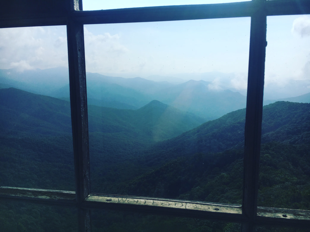
A night at Birch Spring Gap means there’s only six miles left between you and the trailhead at Fontana Dam, which makes for an easy third day. Soak it up around the fire pit or make for Shuckstack Fire Tower at mile 29. Shuckstack is not clearly marked, but it lies at the top of the only offshoot trail south of Birch Spring Gap. It takes about a 0.1 mile climb to get there from the AT, but it’s well worth the effort.
One of four historic lookout towers that remain in Great Smoky Mountains National Park, the old 200-foot tall structure is mostly abandoned, but has been repaired and maintained at least slightly over the years. The views are decent at the bottom, but (carefully) climb the stairs to the top of the steel structure for gorgeous, 360-degree views. Look for the Great Smoky Mountains to the north and east, the Snowbird and Nantahala Mountains to the south, and the Unicoi Mountains to the west. It’s not in the best condition, so be careful walking around on the wooden floor at the top (some sections are rotting).
Take some time to catch your breath and eat some lunch before a final descent back to Fontana.
From here, it’s all downhill. The AT takes a sharp dive back toward the dam—the one avoided by taking Eagle Creek in—and spits out adjacent to the starting point. Blisters and bruises and sweatiness aside, this hike offers rewards well worth the tribulations to get there and back.
How to Get There
The roads are paved and the trails clearly marked, but getting to the top of Fontana Dam and the gravel parking lot for the Lakeshore Trail may be as much fun as the hike itself—almost.
From Knoxville, following the infamous U.S. Highway 129 (Alcoa Highway out of Knoxville) southeast into the mountains. Also known as the Tail of the Dragon, the winding road holds 318 curves in an 11-mile stretch, most of which fall before a turnoff onto Highway 28 just past Deal’s Gap Motorcycle Resort.
Continue on several miles to Fontana Dam Road, which will twist up the hillside to the top of Fontana Dam. Watch for AT thru hikers walking across, the narrow dam is technically part of the trail and sits just north of the "Fontana Hilltop," a luxury shelter along the AT.
Originally written by RootsRated.
Featured image provided by Clay Duda