
 South America Parque Cerro Castillo.
 Lauren Reed lives in Utah, and is currently traveling the length of the Americas by non-motorized means with her hiking partner.
As we flew into Ushuaia, Argentina, over snowy mountain peaks, I tried to predict what our journey on foot would bring. My hiking partner, Bethany, had been dreaming of traveling the length of the Americas since 2011. Over the next few years I occasionally asked about her evolving plan. By January 2015, I was fully committed. So the start of the trek in late November 2015 was a long time coming.
Until that point, I’d done much of my long-distance hiking–on the Appalachian, Pacific Crest, Colorado, and Continental Divide trails–in the U.S. and alone. Bethany was no stranger most of those trails, but had also trekked through Wales, Scotland, and Nepal.
So when Bethany and I began talking logistics, we soon discovered a mutual desire to tell the stories of women we met along the way. Dubbing our planned trek Her Odyssey, it became a mission to travel the length of the Americas by non-motorized means, gather stories along the route, and inspire others to pursue their own audacious dreams.
With that intention, we bought our tickets, packed our packs, and finally we got on our way. As we landed in Argentina, I was still unsure of exactly where this trip would take me. All I knew was it would be very different from the previous 8,000 miles I had walked.
Scrapping our route plan
Bethany and I began our journey by immediately throwing out our route plan. Local guides in Ushuaia told that our original plan to cross into Chile and hike north to Bahia Inutil would be illegal since there would be no border guards to stamp our passports.

Lauren Reed
We were still able to start along the Beagle Channel, beginning our walk in Parque Nacional Tierra Del Fuego. I was relieved by this, as our new route was less remote had more bailout points if needed. As Bethany and I walked, with a stiff breeze of salty sea air blowing us forward towards the mountains still capped with snow, I was feeling many emotions: fear, trepidation, and giddy excitement for our finally unfolding adventure.

Lauren Reed
We spent the next eight days walking across the vast woodlands of Tierra Del Fuego, seeing only a few fishermen along the way. Walking constantly with a hiking partner was a new thing for me. There was no trail, so we agreed to stay in sight of each other at all times. One morning soon after leaving camp, I was walking a few yards ahead of Bethany and went into the woods at the edge of a meadow. Bethany started calling out to me frantically, and I turned around to see what was going on. As it turns out, my green rain jacket and grey pants blended in perfectly with the surrounding woodlands. Since my trail name is “Neon,” we called this new game “Finding Neon.”
Crossing into Chile
Bethany and I made our way across the island of Tierra del Fuego in about two weeks, crossing our first frontera (country border) on foot into Chile, and continued across the Strait of Magellan to our first mainland town, Punta Arenas. I was put in charge of border crossings because my lesser Spanish-language skills prompted fewer questions from the guards.
Armed with a new set of maps fromSIG Patagon, we left Punta Arenas. We pushed through a driving rain but were forced to stop early that evening. We awoke the next morning to a light dusting of snow, through which we walked on, trying to keep ourselves warm in the face of an unrelenting wind.
We crossed to the Pacific Ocean side of the continent, and walked along the cold, windblown beaches of a couple bahias, or bays, up to Estancia Rio Verde and beyond. A valley led us into a turba, or peat moss bog, which we slogged through for a couple of days before coming out the other end, soaked to the knees and happy to see solid ground.

Lauren Reed
Bethany and I walked into the town of Puerto Natales shortly before Christmas. Puerto Natales is the nearest town to Parque Nacional Torres Del Paine, and its world-famous spires were on the horizon. After resupplying and filling our bellies, we encountered many English speakers congregated at Erratic Rock Hostel, which is owned and run by brothers from Oregon. The folks at Erratic Rock were excited to hear about our journey and we, in turn, picked their brains about what we should expect outside of the park.
Our plan for Torres Del Paine was to follow backroads to the park, hike the most common trek in the park (the W route), exit out the other side, and continue to El Calafate, Argentina. As Bethany and I walked towards Torres Del Paine, the mountains slowly drew closer. We had seen some mountains along the trek so far, though these were the first big ones since the beginning.

Lauren Reed
New Year’s Eve with expats
From Campo Italiano, a campground tucked into the mountain valley, we could hear a nearby hanging glacier calving. On New Year’s Eve morning we walked up to Cerro Torres and saw its famous spires. My spirits soared as we walked a lesser used area along the edge of the park toward Lago Azul on New Year’s Eve.

Lauren Reed
We made it to a small camping area after a hot, dusty walk along a dirt road. Soon thereafter we were invited to a New Year’s Eve Asado the campground host was making for a small tour group from Tennessee. “You should be with your people on this holiday,” our host argued. So we ate and celebrated into the night, until Bethany and I were too exhausted to continue and slipped off to our tent.
Need for maps, permission
We continued across beautiful country and another frontera to the town of El Calafate. Unfortunately at this point, SIG Patagon maps had ceased to guide us, so we were on another mission in El Calafate to find new maps. We wandered the town and finally found something decent but, unfortunately, not very detailed.

Lauren Reed
We also stopped by the national park office to let them know our plans to go off trail. Initially told we couldn’t go the way we planned, Bethany and I felt frustrated trying to convince the authorities we were indeed capable. Eventually the backcountry ranger said it was doable on a path he’d cairned through the area.
Finally in possession of a map and the park’s permission in writing, we were off to walk around Lago Argentino and through Parque Nacional Los Glaciares. After bushwhacking several kilometers through hellish amounts of calafate plants, we were able to find the cairns that marked the trail and followed them to an estancia and the ranger station at the end of a road.

Lauren Reed
Bethany and I made our way into the town of El Chalten, nestled in the valley at the base of the Fitz Roy Spires. El Chalten has become a world famous rock climbing destination, and the tourist season was in full swing when we arrived. Overwhelmed by the amount of people milling about, we quickly resupplied, stuffed our faces, and left. We walked back into Los Glacieres National Park in the shadows of glaciers and rocky spires.
Women met, teamwork solidied
We made it to the frontera in two days, and crossed back into Chile and across Lago O’Higgins to the small town of Villa O’Higgins where we met some wonderful women. They helped re-energize and refocus me on our trek’s mission by simply being themselves. Bethany and I walked out of town and along the Ruta de Los Pioneros, a beautiful and little-known (outside of Patagonia) trail that took us along the shores of two lakes, past two gauchos’ (ranchers) homes, up past multiple hanging glaciers, and down into Cochrane. This ruta was one of my favorite sections, as its beauty was all encompassing.

Lauren Reed
Though we lost our way at least once day, I felt a strange calm through this section, perhaps because by then Bethany and I had become a team, not just two people walking together. We were able to troubleshoot and problem solve like pros. Bethany is the best cow path finder/follower I’ve ever met, and I’m good at reading maps and terrain.
From Cochrane, Bethany and I walked to Chile Chico. We crossed Lago General Carrera and found some remnants of the elusive Sendero de Chile, which also coincides with the current southern terminus of the Greater Patagonia Trail.
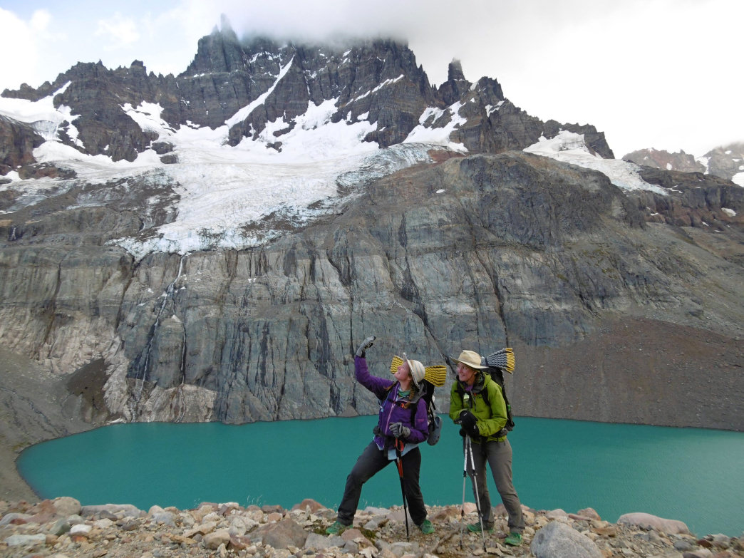
Bethany and I followed those paths into and across Parque Cerro Castillo, a beautiful and well travelled national park. Even though it was terribly windy and rainy, everyone we encountered walking the trail was in high spirits and friendly, giving us unsolicited information about the trail ahead.
Friends of friends open their doors
From Cerro Castillo, Bethany and I walked into the regional capital of Coyhaique (pronounced coy-eye-kay) and stayed a few days with friends of friends. One of the women we met in Villa O’Higgins led us to a woman in Coyhaique who led us to the woman in Futaleufu–and that’s just a hint at the wide network of people we tapped into on this journey. Friendship and familial love run very deep in Chile and Argentina. At first it was overwhelming to me, an introvert, to join families around their dinner tables for hours of conversation.
In Coyhaique we heard about a trail heading out from Lago Verde, a smaller community we reached. We were able to locate it easily, and followed it across a couple of valleys into the town of Palena. From Palena, we walked on the road into the town of Futaleufu where we again stayed with friends of friends.
Leaving Futaleufu, we were noticing more and more leaves changing color, and had an inkling our hiking season was coming to an end. I was feeling conflicted, both ready to be home again and wanting to continue exploring these amazing countries.

Lauren Reed
We crossed back into Argentina and found the southern terminus of the Huella Andina, a long-distance trail stretching up to San Martin de Los Andes. We followed the Huella into and across Parque Nacional Los Alerces and then into Cholila. I was struggling with persistent illness, so we took a couple days off from hiking.
Deciding to stop
Having recovered and crossed through the national park Parque Nacional Nahuel Huapi, we came upon the town of Bariloche, where we ended our trek due to the cold and wet weather moving in. We had walked from late November to late April, and winter was approaching (the seasons in the southern hemisphere are opposite ours in the northern hemisphere).

Lauren Reed
Accepting the end of the hiking season was not easy. Bethany and I debated for a couple of days what we should do. Eventually we admitted that continuing to hike was potentially dangerous to our well being. Snow was starting to accumulate at higher elevations and the western wind was frigid.

Lauren Reed
Over six months, we walked about 2,500 kilometers (more than 1,550 miles) across Patagonia, which encompasses the southern end of both Argentina and Chile. From that experience I learned I am a morning person who likes routine and planning, hates being whacked in the face while breaking trail through brush, and am fearful of sounding stupid to strangers. My hiking partner Bethany is not a morning person, hates alarm clocks, has an entertaining sense of humor, and can follow through on a five-year plan many people would call crazy. But we both love empanadas and orange Fanta.

Lauren Reed
Bethany and I have vowed to return in early November 2016 to Bariloche, where we left off, to continue traveling the length of the Americas by under our own power. We are hoping to not have to take another full season off as we near the Equator. We’re guessing we’ll log some 20,000 miles, which means we have about 18,000 miles to go. If we can finish the South American leg in 2018, look for us to make it “North to the Future” (the state motto of Alaska) in 2020. For updates, go to Her Odyssey.

Lauren Reed
Originally written by RootsRated for Craghoppers.
Featured image provided by Lauren Reed