
 Saguaro National Park.
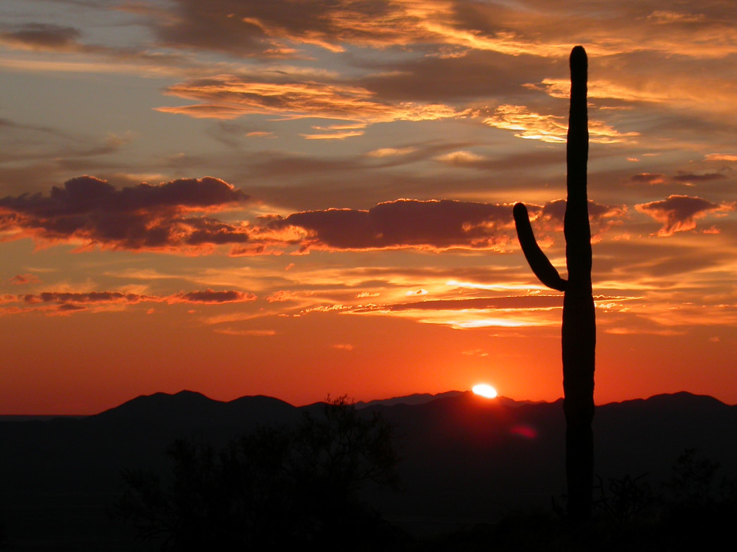
 The iconic Saguaro cactus is the very embodiment of the Southwest, and indeed, the desert itself. The very word conjures up images of rolling purple ridges dotted with giant, almost human-like cacti silhouetted against the setting orange-red desert sun, birds and bats darting swiftly about, while coyotes yelp and owls screech, unseen in the coming night. Nestled in southeast Arizona's Sonoran desert, Saguaro National Park protects these namesake "Desert Monarchs." Saguaros are the largest cacti in North America, they can grow to 70 feet, weigh eight tons, and can live for 200 years.
President Herbert Hoover established the area as a national monument in 1933. It was upgraded to full National Park status in 1994, and now encompasses 91,442 acres of wilderness that is as beautiful as it is harsh. During the Great Depression, the Civilian Conservation Corps was extremely active in the park, building everything from serpentine erosion barriers to the many road signs, picnic benches, and shelters visitors still enjoy to this day.
The park ranges from an elevation of 2,180 to 8,666' and contains six distinct biomes, from desert scrub and grasslands, to oak and pine woodlands to mixed conifer forest. It's this range of climates that gives Saguaro its extraordinarily diverse wildlife. Two hundred species of birds nest in the park, including 18 species of hummingbirds, roadrunners, great-horned owls, and red-tailed hawks. Saguaro also has 50 reptile species including six different rattlesnakes, Gila monsters, iguanas, and a colorful variety of lizards. Jackrabbits, mule deer, javelina, coyote, bobcat, desert tortoise, and even black bear call the park home.
The unique adaptations that vegetation comes up with for desert survival make some of the most interesting, unusual, and beautiful plants in the country. Wildflowers such as striking gold poppies and desert marigolds, red and pink penstemons, purple lupines, and orange globe mallows add welcome splashes of color. Seeing a blooming cactus is a special treat: ocotillos, chollas, and prickly pears all have vibrant, fragrant blossoms, as of course do the saguaros themselves.
Classic Adventures

Harvey Barrison
The park is divided by the city of Tuscon into two districts: the western Tucson Mountain District and the eastern Rincon Mountain District, about an hour apart from each other.
The eastern section is larger and more mountainous, the western portion is lower in elevation and boasts a denser saguaro forest. The east has more hiking trails and is the only region where backpacking is allowed, the west is the better choice if time is short. Between both districts there are over 165 miles of trails.
West Tucson Mountain District
A good way to get a sense of the park is to drive the unpaved scenic Bajada Loop. It's 6 miles long, with excellent views of the foothills, numerous opportunities for fantastic photos, gorgeous shaded picnic areas, and several trailheads. When ready to stretch the legs, hit the Signal Hill Trail, an easy, half-mile walk with expansive, 360-degree views and hundreds of ancient petroglyphs. When done there, have lunch at the shaded Ez-Kim-in-Zin picnic area, rated by a local publication as a candidate for the "most scenic picnic area in a park."
The Kings Canyon trail takes hikers to the 4,687-foot Wasson Peak, the highest summit in the Tucson Mountains. This moderate hike is 6.5 miles round trip with 1,939 feet of elevation gain through paloverde trees, prickly pear and barrel cacti, cholla, ocotillo, mesquite, mature saguaros, and exquisite panels of petroglyphs.
East Rincon Mountain District
First off, drive the 8-mile Cactus Forest Loop Drive for incredible views of the Rincon Mountains. Several excellent hikes of varying distance and difficulty begin off this road. The easy 1-mile Freeman Homestead Trail is one of the best short hikes to get up close to some of the biggest, most mature saguaros in the park.
To learn about desert life, the Desert Ecology Trail has interesting interpretive signs describing the plants and animals that inhabit the Sonoran Desert, and some activities for kids.
Road cyclists have the popular 8-mile Cactus Forest Loop in the easy, and the 6-mile gravel Bajada Loop in the west. There are a couple of trails for mountain bikers as well, the 2.8-mile Hope Camp Trail, and the 2.5 miles of Cactus Forest Trail circled by the Loop Drive. There is a Ramada right inside the park that has cold water, and the visitor's center has bathrooms. If riding into the park from town, riders can avoid the $5 fee by riding in with a local with an annual pass, they get two cyclists per pass.
Immerse Yourself

The other side of Saguaro NP, where forested hills rise from the desert.
The Tanque Verde Ridge Trail is classic. It's an 18-mile round trip with 4,750 feet of vertical gain along a narrow, steep ridgeline en route to the highest point on the ridge, the 7,049-foot Tanque Verde Peak. The trek passes through all six biotic zones of the area, starting with cholla, prickly pear and stands of saguaro. Then through ocotillo, agave and yucca, followed by pinyon-juniper trees and cooler ponderosa pine forests. The trip rewards hikers with uninterrupted views of the entire Tucson valley, the Rincon, Santa Catalina, and Santa Rita mountains, as well as excellent wildlife viewing opportunities. If that sounds like too much for a day, consider camping at Juniper Basin at mile 6.8 for an easier overnight. There are a few tent sites and a privy.
How to Get the Most Out of Your Visit

Harvey Barrison
- A permit is required for overnight stays in the backcountry, the fee is $6 a night per campsite.
- Assume you’re carrying all your own water, a gallon per person, per day. Any sources in Saguaro Wilderness are very intermittent streams or springs. If hiking an out-and-back, consider caching water along the trail.
- Visitors centers and the Rincon District bike ramada have water filling stations to refill reusable water bottles.
- Stay on the trails and watch where you place hands and feet. Cacti are sharp and spiky, and scorpions and rattlesnakes inhabit the area.
- October through April are the best times to visit, summer often bring triple-digit temps.
- There are no campgrounds accessible by road in the park, the closest is a 5.9-mile hike to Douglas Spring. Other camping is found at Spud Rock, Happy Valley, Juniper Basin, Grass Shack, and Manning Camp. Manning Camp is the largest campground in the park, with six sites and a year-round water source. It features a cabin built in 1905 by a former Mayor of Tucson, and is on the national register of historic places. The Park Service now uses it for trail and fire crews, researchers and rangers.
- To gauge a saguaro’s age, know this: a saguaro won’t grow any flowers until it’s 35, and it won’t get its first arm until it’s 50-75 years old.
- OK, so not actually in the park itself, but someplace that should absolutely not be missed, is a visit to the Arizona-Sonora Desert Museum. Its 97 acres house 56,000 individual plants from 1,200 native species and 230 native mammals, reptiles, amphibians, insects, and birds including a multi-species hummingbird aviary. It also has a stellar aquarium and live animal presentations. It’s less than two miles from the Park’s west entrance.
Originally written by RootsRated.
Featured image provided by National Park Service Digital Image Archives