
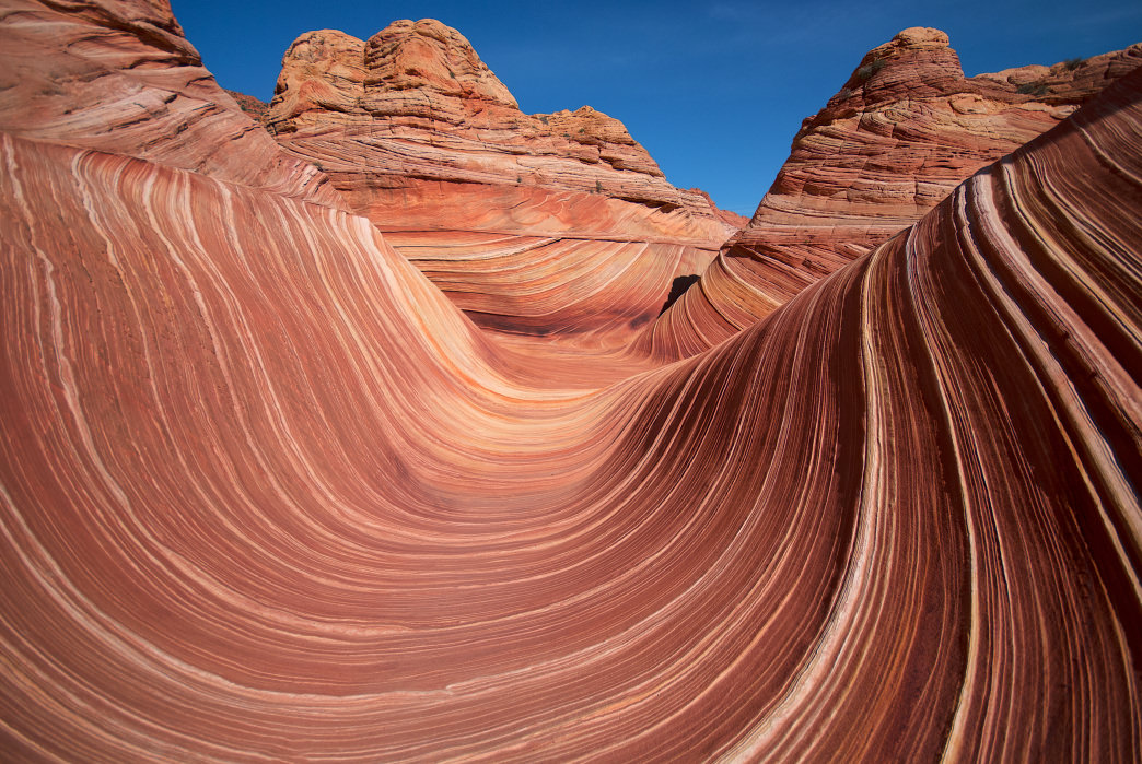
 The Wave in the Coyote Buttes area by the Arizona border is beautiful with its curved strata breaking like a sandstone wave.
 Raw nature surrounds Kanab, a Wild West town in the red heart of southwest Utah's rugged canyon country. Filled with friendly locals, classy dining, lodging and campgrounds, and interesting historical sites, the compact town, lying near the Arizona border, is the gateway to three iconic national parks, five national monuments, a national recreation area, and a couple state parks. These spectacular parklands, all a day trip from Kanab, are realms of solitude, freedom, rock, and sky. The Kanab area also offers a wealth of outdoor adventures, including hiking, photography, off-roading, canyoneering, rock climbing, mountain and road biking, sightseeing, and some of Utah's best scenic drives.
Mormon farmers first settled Kanab, meaning "place of the willows" in Paiute in the 1860s, but the unpredictable Kanab Creek flash-flood in 1883, gouging a deep arroyo. The pioneers persevered and turned to ranching until Hollywood discovered the area's natural beauty in the 1920s. Over 150 television series and films have been shot in the area, including The Lone Ranger, Gunsmoke, and The Greatest Story Ever Told. Since those early days, Kanab has become more than a stopover for national park visitors and now serves as a basecamp for exploring the area's natural wonders. Here's a look at the best activities and places around Kanab—“The Greatest Earth on Show.”
Zion National Park

Shahid Durrani
Zion National Park, one of Utah's crown jewels, spreads across 146,597 acres of deep canyons, soaring cliffs, and sculptured sandstone mountains about 35 miles northwest of Kanab. The busy park, composed of eight geologic formations, is dissected by the 2,300-foot-deep Zion Canyon, a dramatic gorge carved by the Virgin River. Most visitors explore Zion by riding a park shuttle to hiking trails that lead to overlooks, seeping springs, and hidden side canyons. You can access the park from Kanab on the twisting Zion-Mt. Carmel Highway, passing Checkerboard and Crazy Quilt Mesas as well as Canyon Overlook and East Rim trails, before passing through a long tunnel into Zion Canyon. If you want to get away from summer crowds, head for the remote Kolob Canyons on Zion's west side.
Coral Pink Sand Dunes State Park

Yuxin Wei
Coral Pink Sand Dunes State Park, lying west of Kanab, is a natural wonder of red sand dunes pressed against the edge of the Moquith Mountains. Westerly winds carry tiny grains of sand, composed of eroded Navajo sandstone, and shapes them into high rippled dunes. The 3,730-acre state park is the only dune field on the Colorado Plateau. You can study the unique plants and animals living there including the rare Coral Pink beetle, or drive off-highway vehicles (OHVs) on over 2,000 sandy acres. Four-wheel riders like the South Boundary Trail and Sand Highway for family off-road fun.
Grand Staircase-Escalante National Monument
The immense 1.88-million-acre Grand Staircase-Escalante National Monument protects a huge swathe of wild Utah, with a rough landscape of sandstone domes, slickrock canyons, and wonderlands of rock eroded in fanciful shapes. It takes a lifetime to explore the monument and discover its secrets, but if you spend a few days out in its vastness you'll return a changed person. The best way to reach the monument from Kanab is by following either Highway 12 Scenic Byway along its northern boundary or driving up Johnson Canyon and Skutumpah roads through stunning desert country. Stop along the way to hike in Bull Creek Gorge and down the Willis Creek Narrows, or discover treasures like Calf Creek Falls and magnificent Grosvenor Arch. A great side-trip is the rough 57-mile Hole-in-the-Rock Road to one of Utah's best viewpoints.
Kodachrome Basin State Park

Cathy Palopoli
Kodachrome Basin State Park is a compact 2,240-acre parkland tucked against the northwest edge of Grand Staircase-Escalante National Monument. This small but spectacular state park, named for its garish Kodachrome film colors, protects 67 bizarre rock pillars, called sand pipes that rise from six to 170 feet high. It's unknown how these stone sentries formed. Exploring the park is a fun day trip from Kanab, with six trails winding among the towering rock formations. The six-mile Panorama Trail explores the western side of the park, passing Cool Cave and Secret Passage, while the 1.7-mile Shakespeare Arch/Sentinel Trail accesses soaring Shakespeare Arch. Campers can stay overnight in two campgrounds.
Bryce Canyon National Park

Yuxin Wei
Bryce Canyon is a fairyland of standing hoodoos or skinny sandstone spires crammed into four square miles in Bryce Amphitheater just an hour's drive north of Kanab. The strange formations, thought by the Paiute Indians to be rock-frozen people, glow yellow, orange, and red in bright sunlight. Come at sunrise for the best incandescent colors, but don't forget a jacket. It's chilly at 8,000 feet above the hoodoos. The best way to see the park is by foot, following trails that twist among the maze of spires. Favorite hikes are the 5.5-mile Peekaboo-Queens Garden Loop, the eight-mile Fairyland Loop Trail, and the short Moss Cave Trail. Expect solitude and privacy in the backcountry. Cyclists enjoy a 22-mile paved trail on the rim that's closed to motor vehicles.
Buckskin Gulch, White Pocket, and The Wave

Fort Union
The Kanab area is a national scenic treasure with some of the planet's most spectacular vistas and rock formations. Buckskin Gulch, The Wave, and White Pocket, all east of Kanab, are three special areas that are simply out of this world.
Buckskin Gulch, one of the longest and deepest slot canyons in the United States, runs more than 13 miles to Paria Canyon. Hiking Buckskin is an extreme adventure, with wading, scrambling, and swimming through its dark passage. The best hike starts at Wire Pass Trailhead and heads down the canyon to the Paria River, then back to White House Trailhead for a 21-mile loop.
White Pocket is an impressive and remote area of swirling sandstones reached by a long 4×4 road in northern Arizona's Vermilion Cliffs National Monument. Photographers and hikers love exploring its slickrock sculptures reflected in pools of water.
The Wave in the Coyote Buttes area by the Arizona border is beautiful with its curved strata breaking like a sandstone wave. Visitation at the fragile area is limited to 20 people a day. Permits can be reserved ahead through an online lottery or by showing up at the Grand Staircase-Escalante National Monument Visitor Center in Kanab for next-day hikes. Nearby are more wonders like Melody Arch, Top Rock, Sand Cove, and the Second Wave.
Originally written by RootsRated for Utah Office of Tourism.
Featured image provided by John Fowler