
 The many wonders of Honey Creek loop include caves and climbing.
 The most difficult trail in the Big South Fork is also its most beautiful, and many locals say Honey Creek Loop is their favorite hiking destination in East Tennessee. After all, it’s not every day that you find a trail that lets you descend fern-skirted hillsides, gaze up at high stone rock houses, scramble across boulders, explore caves, rest by the river side, climb ladders, rock-hop through creek beds, and ascend to stunning overlooks—all in one trek.
Honey Creek Loop may be moderate in length—just 5.6 miles—but don’t underestimate the challenge in store, thanks to its strenuous terrain and its numerous obstacles. You’ll want to devote at least 5 hours to the excursion. And keep in mind that more people get lost on the Honey Creek Loop than any other trail in the Big South Fork, so hiking experience and solid navigational skills come in handy.
But every bit of effort is worth it: Traveling around the loop, hikers feel like they are passing through numerous distinct ecosystems, each with its own challenges and appeal.
Still haven’t discovered Honey Creek Loop yet? Our insider tips are the perfect primer. They’ll help you avoid some of the trickier aspects of the trail and inspire you to descend into the deep hidden valleys of Big South Fork to see for yourself the hidden wonders of this magical trail.
The First Challenge: Getting There

Logan Mahan
The trickiness of Honey Creek Loop starts before you even get there, and many plenty of hopeful hikers never even make it to the trailhead. The parking area is marked as “Honey Creek Loop Trail Entrance 2” on Google maps, and the route there will take travelers coming from Knoxville via US-27 or I-75 up Honey Creek Loop Road over Burn Mill Bridge and on up until the road turns to dirt and gravel. You’ll go for 3.1 miles.
If it feels like you’re going the wrong way, it means you’re almost there! The road will fork; stay right on Honey Creek Road, shortly after which you’ll reach the Honey Creek Loop parking lot. We prefer to do the loop in a counterclockwise direction (and a hiker with a Sharpie concurred on the info kiosk at the trailhead), but you can start from either direction. Counterclockwise has a steeper descent, which makes the ascent back to your car at that end a little easier.
The First Half
To access the trailhead for the counter-clockwise loop, walk a short distance north up Honey Creek Road, and climb a staircase on your right. The trail is marked with green blazes.
After about half a mile of easy hiking through ridge-top woods, you’ll descend steeply along a small stream, and soon find yourself surrounded by thick rhododendron. In spring and early summer, ferns and carpets of greenery trace the trail for the first mile. Overhead, deep, narrow, curving lines in the stone indicate where water and time have cut meandering pathways through the rock.
After the first mile or so, a few switchbacks lead down into an area buttressed by a high stone wall. Here, you’ll find a small waterfall or a tiny trickle, depending on the time of year and rainfall.

Logan Mahan
After 1.5 miles, you’ll pass beneath Echo Rock, named for the way it reflects and amplifies the distant sounds of Big South Fork. It’s a perfect spot for a break; perk your ears to see if you can hear the roar of whitewater. Beyond Echo Rock is the junction for the Overlook Trail, which accesses cliff-top views of Big South Fork via two ladders. (Many dogs can’t or won’t make it up these ladders, so if you’ve brought your four-legged friend, you can always drive up the Honey Creek Loop Road—this gravel road is labeled “Alternate Trail” on some maps—after your hike. It dead-ends at the overlook parking lot.)
Head right at the junction of Overlook Trail to descend toward Big South Fork on the main Loop. The trail doesn’t go directly down to the water, but if you want to get your feet wet, don’t worry: There’s plenty of opportunity for that coming up.
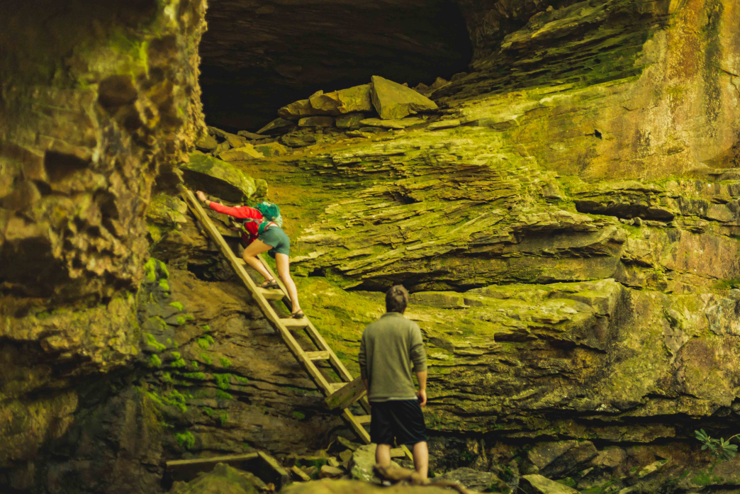
Ladder Climbing and Boulder Scrambling

Logan Mahan
A narrow trail hugs the side of the hill near the river for a short while before reaching the loop’s namesake, Honey Creek. This stream cascades over slick boulders and stone shelves as it makes its way down to Big South Fork. The trail winds along, over, and through the creek for a few miles and you’ll have to hop across boulders and perhaps do a little fording to make it upstream.
The section along Honey Creek offers the most beautiful and most difficult part of the loop. The trail markers become even more difficult to find, and there’s not always a clear, worn-in path due to the constant fluctuations of the creek. The green blazes are supplemented with orange arrows painted on the rocks. Shortly after working your way through Honey Creek, you’ll reach Indian Rockhouse, which can be accessed by the old cage ladder propped at its base.

Logan Mahan
The trail will begin to ascend and you’ll walk along the edge of a high cliff, eventually reaching some large signs directing hikers to the John Muir Trail and the O&W Bridge, Leatherwood Bridge, and Devil’s Den via the Sheltowee Trace. The trail gets a little confusing here. You’ll continue along the main Honey Creek Loop Trail, but the green markers that have marked the trail to this point will be briefly replaced by and interspersed with signs for the Sheltowee Trace.
Continue to follow these; the usual green signs will pop up again soon. There will be an option to tack on an extra 0.6 miles with the Indian Rockhouse Loop—so named for the the large, high-roofed caves along the stretch. If you have time, these huge stone rooms are well worth the extra walking.

Logan Mahan
One of the last and most awe-inspiring stops on the trail is Boulder House Falls, where house-sized rocks have fallen into the stream and created a beautiful cavern of water and light. If the water is low enough, you should be able to walk back up into the cavern. There were no visible cascades on a recent visit, but you could hear the water flowing unseen behind the giant stones. When you’re ready to continue, the trail continues on the opposite side of the stream—get ready for a bit of rock scrambling ahead.
At the 4-mile mark of the loop is a side trail to Honey Creek Falls, after which you’ll ascend through a wooded area much like you descended through in the beginning. This means you only have about a mile left before you’re back at the parking lot. If you didn’t take the overlook trail, don’t forget to drive up and check out the views of Big South Fork before heading home.
If You Go
- Give yourself at least 5 hours to complete the trail.
- If there’s any chance of being on the trail after dark, bring a headlamp.
- More people get lost on the Honey Creek Loop than any other trail in the Big South Fork, so make sure you have solid navigational skills.
- This is not a trail for children, small dogs, or anyone without substantial hiking experience.
- Stop at Burnt Mill Bridge to use the restroom. This will be your last chance before starting the hike.
- Bring plenty of water.
- If you’re going alone, make sure you let someone know your itinerary beforehand.
- Don’t hike this trail in icy conditions or after heavy rains.
Originally written by RootsRated.
Featured image provided by Logan Mahan